
Make a donation
Gear up for your next adventure:
As an Amazon Associate, this site earns from qualifying purchases at no extra cost to you.
Segovia topographic map
Click on the map to display elevation.
Make a donation
Gear up for your next adventure:
As an Amazon Associate, this site earns from qualifying purchases at no extra cost to you.
Segovia
Segovia has a hot-summer Mediterranean climate (Csa in the Köppen climate classification) bordering on a cold semi-arid climate (BSk), resulting from the high altitude and the distance from the coast. The average annual temperature is 12.42 °C (54.4 °F), with an average low in January of 0.3 °C (32.5 °F) and an average high in July of 29.7 °C (85.5 °F). The annual precipitation range from 400 to 500 mm per year in the lower plains, and can reach above 1000 mm in the nearby mountainous area of Sierra de Guadarrama, as rainfall and snowfall is more frequent up the mountains. Decent showers coming from summer thunderstorms help the mountainous area of the province to be rainier than average than most of the central Spanish plateau, which gives the area lush vegetation. All of this make the province a damp corner in the context of the region. The predominant forms of vegetation in the mountainous areas include pine, evergreen, oak, beech and juniper.
Make a donation
Gear up for your next adventure:
As an Amazon Associate, this site earns from qualifying purchases at no extra cost to you.
About this map
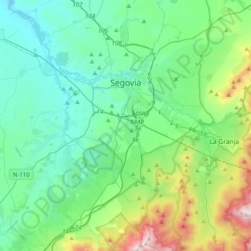
Name: Segovia topographic map, elevation, terrain.
Location: Segovia, Castile and León, Spain (40.83472 -4.33675 40.98799 -4.05245)
Average elevation: 3,750 ft
Minimum elevation: 2,812 ft
Maximum elevation: 7,195 ft
Make a donation
Gear up for your next adventure:
As an Amazon Associate, this site earns from qualifying purchases at no extra cost to you.
Other topographic maps
Click on a map to view its topography, its elevation and its terrain.
Make a donation
Gear up for your next adventure:
As an Amazon Associate, this site earns from qualifying purchases at no extra cost to you.