Geolocate

Bolbok topographic map

Click on the map to display elevation.

About this map

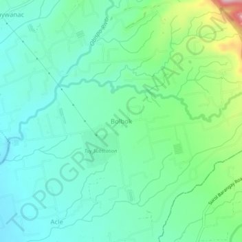
Name: Bolbok topographic map, elevation, terrain.

Location: Bolbok, Tuy, Batangas, Calabarzon, 4214, Philippines (14.00171 120.73923 14.04171 120.77923)

Average elevation: 420 ft

Minimum elevation: 226 ft

Maximum elevation: 1,007 ft

Other topographic maps

Click on a map to view its topography, its elevation and its terrain.

Palico River

Philippines > Batangas > Tuy > Sabang > Palico

Average elevation: 131 ft

Luna

Philippines > Batangas > Tuy

Average elevation: 246 ft

Gear up for your next adventure:

🦶Hiking Gaiters - Keep debris and water out of your boots
🛰️Satellite Messengers - Emergency SOS and two-way messaging for off-grid adventures
🔥Fast-Boil Camping Stoves - Efficient cooking systems for quick trail meals
🎁Geography Themed Gifts - Unique gift ideas for map lovers and geography enthusiasts
🛡️Insect Repellent - Protection against bugs during outdoor activities

As an Amazon Associate, this site earns from qualifying purchases at no extra cost to you.