Geolocate

Luna topographic map

Click on the map to display elevation.

About this map

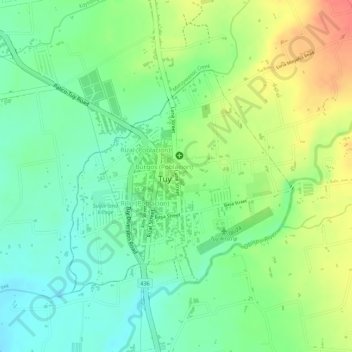
Name: Luna topographic map, elevation, terrain.

Location: Luna, Poblacion, Tuy, Batangas, Calabarzon, Philippines (14.01096 120.73035 14.02727 120.74017)

Average elevation: 246 ft

Minimum elevation: 157 ft

Maximum elevation: 364 ft

Other topographic maps

Click on a map to view its topography, its elevation and its terrain.

Tuy

Philippines > Batangas > Tuy

Average elevation: 279 ft

Sabang

Philippines > Batangas > Tuy

Average elevation: 174 ft

Guinhawa

Philippines > Batangas > Tuy

Average elevation: 157 ft

Putol

Philippines > Batangas > Tuy

Average elevation: 184 ft

Palico

Philippines > Batangas > Tuy > Sabang

Average elevation: 167 ft

Dao

Philippines > Batangas > Tuy

Average elevation: 322 ft

Toong

Philippines > Batangas > Tuy

Average elevation: 1,545 ft

Luntal

Philippines > Batangas > Tuy

Average elevation: 226 ft

Bolbok

Philippines > Batangas > Tuy

Average elevation: 420 ft

Palico River

Philippines > Batangas > Tuy > Sabang > Palico

Average elevation: 131 ft

Dao

Philippines > Batangas > Tuy

Average elevation: 318 ft

Tuyon-tuyon

Philippines > Batangas > Tuy

Average elevation: 217 ft

Tuyon-tuyon

Philippines > Batangas > Tuy

Average elevation: 217 ft

Gear up for your next adventure:

🪶Wildlife Field Guides - Learn animal tracking and species ID
🌡️Portable Weather Meter - Track weather conditions on the trail
🎒Outdoor Daypacks - Lightweight backpacks designed for carrying maps and essential gear
🎒Trail Energy Bars - High‑calorie bars for hiking energy
🧯Portable Fire Pit - Compact fire pit for camping spots

As an Amazon Associate, this site earns from qualifying purchases at no extra cost to you.