Geolocate

Anchorage topographic map

Click on the map to display elevation.

About this map

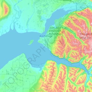
Name: Anchorage topographic map, elevation, terrain.

Location: Anchorage, Alaska, United States (60.73379 -150.42062 61.48394 -148.46001)

Average elevation: 1,037 ft

Minimum elevation: -7 ft

Maximum elevation: 7,503 ft

Alaska trails, hiking, mountain biking, running and outdoor activities

Other topographic maps

Click on a map to view its topography, its elevation and its terrain.

Beluga Point

United States > Alaska > Anchorage

Average elevation: 427 ft

Overlook Acres

United States > Alaska > Anchorage

Average elevation: 850 ft

Windemere

United States > Alaska > Anchorage

Average elevation: 108 ft

Spenard

United States > Alaska > Anchorage > Spenard

Average elevation: 95 ft

Gear up for your next adventure:

📷Action Camera - Capture your outdoor adventures in HD
🧯Portable Fire Pit - Compact fire pit for camping spots
🔊Portable Camp Speaker - Music and alerts at camp
🛠️Backpacking Tool Kit - Essential toolkit for outdoor repairs
🦶Hiking Gaiters - Keep debris and water out of your boots

As an Amazon Associate, this site earns from qualifying purchases at no extra cost to you.