Geolocate

Doade topographic map

Click on the map to display elevation.

About this map

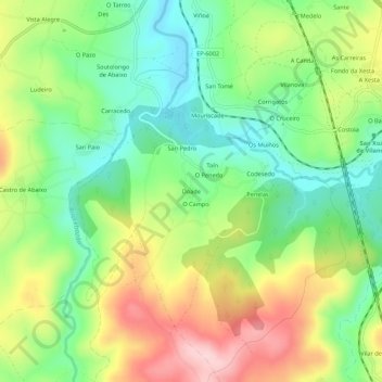
Name: Doade topographic map, elevation, terrain.

Location: Doade, Lalín, Deza, Pontevedra, Galicia, 36519, España (42.58634 -8.16248 42.62634 -8.12248)

Average elevation: 1,808 ft

Minimum elevation: 1,493 ft

Maximum elevation: 2,267 ft

Other topographic maps

Click on a map to view its topography, its elevation and its terrain.

Zobra

España > Galicia > Deza > Lalín

Average elevation: 2,270 ft

Bendoiro

España > Galicia > Deza > Lalín

Average elevation: 1,555 ft

Busto

España > Galicia > Deza > Lalín

Average elevation: 2,011 ft

Cercio

España > Galicia > Deza > Lalín

Average elevation: 1,539 ft

Rodís

España > Galicia > Deza > Lalín

Average elevation: 1,414 ft

Gear up for your next adventure:

🪶Compact Camp Shovel - Folding shovel for campsite tasks
🔭Stargazing Telescopes - Perfect for camping in low-light pollution areas shown on maps
🦺Reflective Outdoor Gear - Safety gear for low‑light conditions
🕶️GPS Smartphone Mount - Secure mount for phone navigation
📡Handheld GPS Device - Reliable handheld GPS for outdoor navigation

As an Amazon Associate, this site earns from qualifying purchases at no extra cost to you.