Geolocate
👉 Easily get elevation data in JSON, GeoTIFF and KML formats using Elevation API
Thank you for supporting this site ❤️
Make a donation

Busto topographic map

Click on the map to display elevation.

About this map

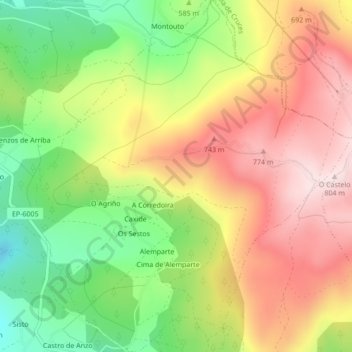
Name: Busto topographic map, elevation, terrain.

Location: Busto, Lalín, Deza, Pontevedra, Galicia, España (42.71874 -8.19577 42.75024 -8.15739)

Average elevation: 2,011 ft

Minimum elevation: 1,362 ft

Maximum elevation: 2,628 ft

Other topographic maps

Click on a map to view its topography, its elevation and its terrain.

A Goleta

España > Galicia > Deza > Lalín

Average elevation: 1,640 ft

Samprizón

España > Galicia > Deza > Lalín

Average elevation: 2,195 ft

Castro de Abaixo

España > Galicia > Deza > Lalín

Average elevation: 1,831 ft

Bustelos

España > Galicia > Deza > Lalín

Average elevation: 2,224 ft

Doade

España > Galicia > Deza > Lalín

Average elevation: 1,808 ft

Erbo de Arriba

España > Galicia > Deza > Lalín

Average elevation: 1,801 ft

A Estrada

España > Galicia > Deza > Lalín

Average elevation: 1,696 ft

Palmou

España > Galicia > Deza > Lalín

Average elevation: 1,795 ft

O Cruceiro

España > Galicia > Deza > Lalín

Average elevation: 1,535 ft

Soutolongo de Abaixo

España > Galicia > Deza > Lalín

Average elevation: 1,736 ft

Gear up for your next adventure:

🔊Portable Camp Speaker - Music and alerts at camp
📱Heavy-Duty Phone Cases - Drop-proof and waterproof protection for outdoor navigation
🧯Portable Fire Pit - Compact fire pit for camping spots
📱Solar Portable Charger - Solar power bank for charging devices off‑grid
🦶Carbon Trekking Poles - Reduce knee impact on steep descents with ultra-light poles

As an Amazon Associate, this site earns from qualifying purchases at no extra cost to you.