
Florida topographic map
Click on the map to display elevation.
Florida
Florida is a town in Berkshire County, Massachusetts, United States. It is part of the Pittsfield, Massachusetts Metropolitan Statistical Area. It is home to the east portal of the Hoosac Tunnel, as well as Whitcomb Summit (elevation 2,172 ft or 662 m), the highest point of the Mohawk Trail. Florida contains the village of Drury. At the 2020 census the town had a total population of 694. Despite the town’s name, Florida is statistically the coldest and snowiest town in Massachusetts.
About this map
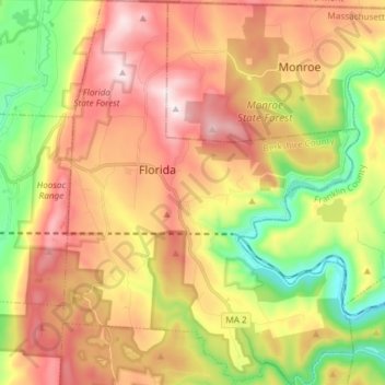
Name: Florida topographic map, elevation, terrain.
Average elevation: 1,722 ft
Minimum elevation: 620 ft
Maximum elevation: 2,818 ft
Berkshire County trails, hiking, mountain biking, running and outdoor activities
Other topographic maps
Click on a map to view its topography, its elevation and its terrain.
Taconic Mountain Wildlife Management Area
United States > Massachusetts > Berkshire County > Williamstown
Average elevation: 1,995 ft
June Mountain
United States > Massachusetts > Berkshire County > Sheffield
Average elevation: 1,115 ft
Lake Averic
United States > Massachusetts > Berkshire County > Stockbridge > Interlaken
Average elevation: 1,070 ft
Camp Merrill
United States > Massachusetts > Berkshire County > Pittsfield
Average elevation: 1,158 ft
Braytonville
United States > Massachusetts > Berkshire County > North Adams
Average elevation: 1,027 ft
North Adams
United States > Massachusetts > Berkshire County > North Adams > North Adams
Average elevation: 1,362 ft
Beachwood
United States > Massachusetts > Berkshire County > Stockbridge > Beachwood
Average elevation: 1,040 ft
Berkshire South
United States > Massachusetts > Berkshire County > Great Barrington
Average elevation: 873 ft
Root Orchards
United States > Massachusetts > Berkshire County > Great Barrington > Housatonic > Risingdale
Average elevation: 912 ft
Natural Bridge State Park
United States > Massachusetts > Berkshire County > North Adams
Average elevation: 1,043 ft
West New Boston
United States > Massachusetts > Berkshire County > Sandisfield
Average elevation: 1,168 ft
Indian Lake Association
United States > Massachusetts > Berkshire County > Becket
Average elevation: 1,493 ft
Tyringham Cobble
United States > Massachusetts > Berkshire County > Tyringham
Average elevation: 1,142 ft
Bonny Rigg Corners
United States > Massachusetts > Berkshire County > Becket
Average elevation: 1,476 ft
South Mountain
United States > Massachusetts > Berkshire County > Pittsfield
Average elevation: 1,106 ft