
Thank you for supporting this site ❤️
Make a donation
Make a donation
Gear up for your next adventure:
As an Amazon Associate, this site earns from qualifying purchases at no extra cost to you.
Guilhado topographic map
Click on the map to display elevation.
Thank you for supporting this site ❤️
Make a donation
Make a donation
Gear up for your next adventure:
As an Amazon Associate, this site earns from qualifying purchases at no extra cost to you.
About this map
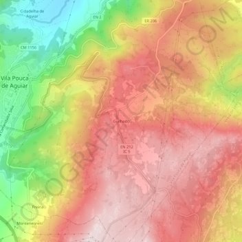
Name: Guilhado topographic map, elevation, terrain.
Location: Guilhado, Vila Pouca de Aguiar, Vila Real, 5450-042, Portugal (41.47426 -7.64073 41.51426 -7.60073)
Average elevation: 2,949 ft
Minimum elevation: 2,014 ft
Maximum elevation: 3,556 ft
Thank you for supporting this site ❤️
Make a donation
Make a donation
Gear up for your next adventure:
As an Amazon Associate, this site earns from qualifying purchases at no extra cost to you.
Other topographic maps
Click on a map to view its topography, its elevation and its terrain.