
Make a donation
Gear up for your next adventure:
As an Amazon Associate, this site earns from qualifying purchases at no extra cost to you.
Bragado topographic map
Click on the map to display elevation.
Make a donation
Gear up for your next adventure:
As an Amazon Associate, this site earns from qualifying purchases at no extra cost to you.
About this map
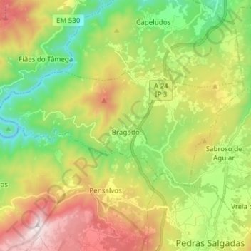
Name: Bragado topographic map, elevation, terrain.
Location: Bragado, Vila Pouca de Aguiar, Vila Real, Portugal (41.56389 -7.70933 41.60864 -7.58539)
Average elevation: 2,060 ft
Minimum elevation: 797 ft
Maximum elevation: 3,927 ft
Make a donation
Gear up for your next adventure:
As an Amazon Associate, this site earns from qualifying purchases at no extra cost to you.
Other topographic maps
Click on a map to view its topography, its elevation and its terrain.
Soutelinho do Monte
Portugal > Vila Real > Vila Pouca de Aguiar > Vreia de Bornes
Average elevation: 1,893 ft
Cidadelha de Jales
Portugal > Vila Real > Vila Pouca de Aguiar > Alfarela de Jales
Average elevation: 2,569 ft