Geolocate

Raymondville topographic map

Click on the map to display elevation.

About this map

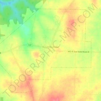
Name: Raymondville topographic map, elevation, terrain.

Location: Raymondville, Texas County, Missouri, 65555, United States (37.32413 -91.86003 37.35287 -91.81655)

Average elevation: 1,329 ft

Minimum elevation: 1,198 ft

Maximum elevation: 1,414 ft

Texas County trails, hiking, mountain biking, running and outdoor activities

Other topographic maps

Click on a map to view its topography, its elevation and its terrain.

Hartshorn

United States > Missouri > Texas County

Average elevation: 1,260 ft

Mineral Springs City

United States > Missouri > Texas County > Houston

Average elevation: 1,188 ft

Gear up for your next adventure:

💧Water Purification System - Clean water on the trail with reliable purifiers
🪓Survival Multi‑Tool - Versatile tool for camp and trail tasks
🎒Trekking Poles - Sturdy poles for balance and stability on rough terrain
🚪Portable Camp Chair - Foldable chair for comfort at camp
🛠️Outdoor Gear Repair Kit - Essential tools to fix gear on the trail

As an Amazon Associate, this site earns from qualifying purchases at no extra cost to you.