Geolocate

Florence topographic map

Click on the map to display elevation.

About this map

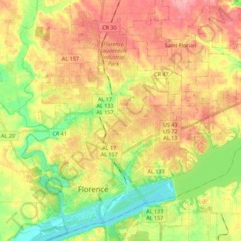
Name: Florence topographic map, elevation, terrain.

Location: Florence, Lauderdale County, Alabama, United States (34.77897 -87.72249 34.89188 -87.57010)

Average elevation: 571 ft

Minimum elevation: 410 ft

Maximum elevation: 725 ft

Lauderdale County trails, hiking, mountain biking, running and outdoor activities

Other topographic maps

Click on a map to view its topography, its elevation and its terrain.

Creekwood

United States > Alabama > Lauderdale County > Florence

Average elevation: 591 ft

Killen

United States > Alabama > Lauderdale County

Average elevation: 594 ft

Rogersville

United States > Alabama > Lauderdale County

Average elevation: 646 ft

Gear up for your next adventure:

❄️Traction Cleats - Prevent slips on icy trails during winter hikes
👓Polarized Sunglasses - Outdoor sunglasses for glare reduction
🧺Microfiber Travel Towels - Compact and fast-drying towels for trail use
🩹Survival Bandages - High‑quality bandages for emergencies
🌎3D Topographic Globes - Raised relief globes for a tactile understanding of geography

As an Amazon Associate, this site earns from qualifying purchases at no extra cost to you.