Geolocate

Manacor topographic map

Click on the map to display elevation.

About this map

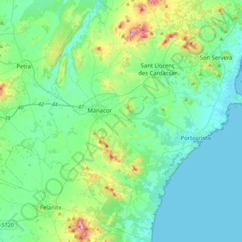
Name: Manacor topographic map, elevation, terrain.

Location: Manacor, Llevant, Balearic Islands, Spain (39.43886 3.12263 39.67890 3.37589)

Average elevation: 292 ft

Minimum elevation: 0 ft

Maximum elevation: 1,562 ft

Other topographic maps

Click on a map to view its topography, its elevation and its terrain.

Cales de Mallorca

Spain > Balearic Islands > Llevant

Average elevation: 82 ft

S'Illot

Spain > Balearic Islands > Llevant

Average elevation: 13 ft

Manacor

Spain > Balearic Islands > Llevant

Average elevation: 328 ft

Portocristo

Spain > Balearic Islands > Llevant

Average elevation: 82 ft

Gear up for your next adventure:

❄️Traction Cleats - Prevent slips on icy trails during winter hikes
🧣Hiking Neck Gaiter - Multi‑use neck protection for outdoor weather
Backpacking Tents - Weight-optimized shelters for multi-day topographic surveys
📷Action Camera - Capture your outdoor adventures in HD
🧤Hiking Gloves - Protective gloves for rugged trails

As an Amazon Associate, this site earns from qualifying purchases at no extra cost to you.