Geolocate

Manacor topographic map

Click on the map to display elevation.

About this map

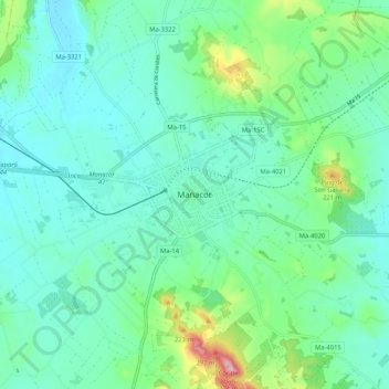
Name: Manacor topographic map, elevation, terrain.

Location: Manacor, Llevant, Balearic Islands, 07500, Spain (39.52965 3.17065 39.60965 3.25065)

Average elevation: 328 ft

Minimum elevation: 148 ft

Maximum elevation: 1,017 ft

Other topographic maps

Click on a map to view its topography, its elevation and its terrain.

Manacor

Spain > Balearic Islands > Llevant

Average elevation: 292 ft

Capdepera

Spain > Balearic Islands > Llevant

Average elevation: 210 ft

S'Illot

Spain > Balearic Islands > Llevant

Average elevation: 13 ft

Son Servera

Spain > Balearic Islands > Llevant

Average elevation: 308 ft

Gear up for your next adventure:

🪶Wildlife Field Guides - Learn animal tracking and species ID
🧢Sun Protection Hats - Wide-brimmed and UPF-rated hats for high-altitude sun safety
🪶Multi‑Purpose Knife - Useful blade for camp and trail
☀️Outdoor Sunscreen - High protection sunscreen for outdoor activities
🥾Women's Hiking Boots - Top-rated trail boots with ankle support and superior grip

As an Amazon Associate, this site earns from qualifying purchases at no extra cost to you.