Geolocate

Geilo topographic map

Click on the map to display elevation.

About this map

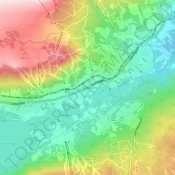
Name: Geilo topographic map, elevation, terrain.

Location: Geilo, Hol, Viken, 3580, Norway (60.51372 8.18897 60.55372 8.22897)

Average elevation: 2,858 ft

Minimum elevation: 2,375 ft

Maximum elevation: 3,737 ft

Other topographic maps

Click on a map to view its topography, its elevation and its terrain.

Aremark

Norway > Viken

Average elevation: 492 ft

Hemsedal

Norway > Viken

Average elevation: 3,993 ft

Nordre Follo

Norway > Viken

Average elevation: 466 ft

Fødalen landskapsvernområde

Norway > Viken

Average elevation: 4,865 ft

Indre Østfold

Norway > Viken

Average elevation: 486 ft

Rollag

Norway > Viken

Average elevation: 2,139 ft

Drammen

Norway > Viken

Average elevation: 686 ft

Moss

Norway > Viken

Average elevation: 75 ft

Flå

Norway > Viken

Average elevation: 2,359 ft

Hvaler

Norway > Viken

Average elevation: 7 ft

Nittedal

Norway > Viken

Average elevation: 971 ft

Gear up for your next adventure:

🎁Geography Themed Gifts - Unique gift ideas for map lovers and geography enthusiasts
🧺Microfiber Travel Towels - Compact and fast-drying towels for trail use
🖼️Topo Map Wall Art - Decorative topographic prints of famous peaks and regions
📖Nature Tracking Books - Learn to track wildlife and terrain
❄️Traction Cleats - Prevent slips on icy trails during winter hikes

As an Amazon Associate, this site earns from qualifying purchases at no extra cost to you.