Geolocate

Blind Lake topographic map

Click on the map to display elevation.

About this map

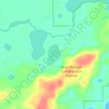
Name: Blind Lake topographic map, elevation, terrain.

Location: Blind Lake, Cass County, Minnesota, United States (46.88790 -94.40924 46.89322 -94.40413)

Average elevation: 1,381 ft

Minimum elevation: 1,306 ft

Maximum elevation: 1,522 ft

Cass County trails, hiking, mountain biking, running and outdoor activities

Other topographic maps

Click on a map to view its topography, its elevation and its terrain.

Birch Lake

United States > Minnesota > Cass County > Hackensack

Average elevation: 1,394 ft

Whipholt

United States > Minnesota > Cass County

Average elevation: 1,322 ft

Moose Lake

United States > Minnesota > Cass County

Average elevation: 1,450 ft

Inguadona

United States > Minnesota > Cass County

Average elevation: 1,325 ft

Boy Lake

United States > Minnesota > Cass County

Average elevation: 1,312 ft

Leech Lake

United States > Minnesota > Cass County

Average elevation: 1,325 ft

East Gull Lake

United States > Minnesota > Cass County

Average elevation: 1,214 ft

Bena

United States > Minnesota > Cass County > Bena

Average elevation: 1,306 ft

Hackensack

United States > Minnesota > Cass County > Hackensack

Average elevation: 1,388 ft

Pine River

United States > Minnesota > Cass County

Average elevation: 1,296 ft

Gear up for your next adventure:

🪶LED Camping Lantern - Bright lantern for camp lighting
🔊Portable Camp Speaker - Music and alerts at camp
⛑️Personal Locator Beacon - Safety beacon for emergencies
👟Trail Running Shoes - Lightweight shoes for trail runners
🧢Outdoor Hiking Hat - Sun protection hat for outdoor explorers

As an Amazon Associate, this site earns from qualifying purchases at no extra cost to you.