Geolocate

Tolyatti topographic map

Click on the map to display elevation.

About this map
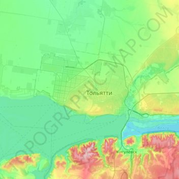
Name: Tolyatti topographic map, elevation, terrain.

Location: Tolyatti, Samara Oblast, Volga Federal District, Russia (53.44636 49.14714 53.59726 49.77655)

Average elevation: 338 ft

Minimum elevation: 79 ft

Maximum elevation: 1,155 ft

Other topographic maps

Click on a map to view its topography, its elevation and its terrain.

Chapaevsk

Russia > Samara Oblast > Chapayevsk

Average elevation: 210 ft

Surgut

Russia > Samara Oblast > Sergiyevsky District

Average elevation: 223 ft

Gear up for your next adventure:

🕶️GPS Smartphone Mount - Secure mount for phone navigation
🚁Photography Drones - Capture stunning aerial views of landforms and topography
🪑Portable Camp Table - Compact table for campsite meals
🚪Portable Camp Chair - Foldable chair for comfort at camp
🦶Hiking Gaiters - Keep debris and water out of your boots

As an Amazon Associate, this site earns from qualifying purchases at no extra cost to you.