Geolocate

Riverbend topographic map

Click on the map to display elevation.

About this map

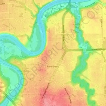
Name: Riverbend topographic map, elevation, terrain.

Location: Riverbend, Edmonton, Alberta, Canada (53.45614 -113.62758 53.50642 -113.54717)

Average elevation: 2,169 ft

Minimum elevation: 2,018 ft

Maximum elevation: 2,310 ft

Other topographic maps

Click on a map to view its topography, its elevation and its terrain.

landslide

Canada > Alberta > Edmonton

Average elevation: 2,192 ft

William Hawrelak Park

Canada > Alberta > Edmonton

Average elevation: 2,129 ft

Horseshoe Lake

Canada > Alberta > Edmonton

Average elevation: 2,231 ft

Ormsby Park

Canada > Alberta > Edmonton

Average elevation: 2,257 ft

Gear up for your next adventure:

🎒Trekking Poles - Sturdy poles for balance and stability on rough terrain
🧴Hand Sanitizer - Keep hands clean while hiking
🩳Quick‑Dry Hiking Shorts - Comfortable and quick‑dry shorts for summer hiking
🧯Portable Fire Pit - Compact fire pit for camping spots
Camping Coffee Makers - Enjoy premium coffee at the summit or campsite

As an Amazon Associate, this site earns from qualifying purchases at no extra cost to you.