Geolocate

Okrokana topographic map

Click on the map to display elevation.

About this map

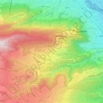
Name: Okrokana topographic map, elevation, terrain.

Location: Okrokana, Tbilisi, 0105, Georgia (41.66738 44.75355 41.70738 44.79355)

Average elevation: 2,287 ft

Minimum elevation: 1,286 ft

Maximum elevation: 3,317 ft

Other topographic maps

Click on a map to view its topography, its elevation and its terrain.

Bukia Garden

Georgia > Tbilisi

Average elevation: 1,457 ft

Isani-Samgori Raion

Georgia > Tbilisi

Average elevation: 2,037 ft

Gear up for your next adventure:

🪑Portable Camp Table - Compact table for campsite meals
🏔️Mountain Trail Maps - High‑detail maps for popular peaks
🎒Day Hiking Backpack - Lightweight backpack perfect for day trips and outdoor adventures
🦶Carbon Trekking Poles - Reduce knee impact on steep descents with ultra-light poles
👓Polarized Sunglasses - Outdoor sunglasses for glare reduction

As an Amazon Associate, this site earns from qualifying purchases at no extra cost to you.