
Make a donation
Gear up for your next adventure:
As an Amazon Associate, this site earns from qualifying purchases at no extra cost to you.
99425 topographic map
Click on the map to display elevation.
Make a donation
Gear up for your next adventure:
As an Amazon Associate, this site earns from qualifying purchases at no extra cost to you.
About this map
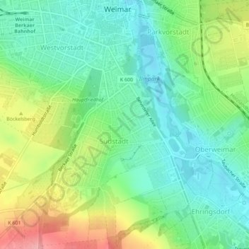
Name: 99425 topographic map, elevation, terrain.
Location: 99425, Südstadt, Weimar, Thüringen, Deutschland (50.96850 11.33079 50.96860 11.33089)
Average elevation: 820 ft
Minimum elevation: 692 ft
Maximum elevation: 1,063 ft
Make a donation
Gear up for your next adventure:
As an Amazon Associate, this site earns from qualifying purchases at no extra cost to you.
Other topographic maps
Click on a map to view its topography, its elevation and its terrain.
Weimar
Deutschland > Thüringen > Weimar > Weimar
Weimar liegt in rund 200 Metern Höhe in der Mitte Thüringens. Die Landschaft wird durch fünf Regionen bestimmt. Durch die Stadt verläuft die Ilm in einem Bogen. Sie tritt bei Taubach im Südosten ins Stadtgebiet ein, fließt weiter durch Oberweimar und die Altstadt, bevor sie unterhalb Tiefurts das…
Average elevation: 925 ft
Ilmpark
Deutschland > Thüringen > Weimar
Bemerkenswert ist auch das Haus Ithaka, das 1907 für den Dichter Ernst von Wildenbruch vom Architekten Paul Schultze-Naumburg auf einer Anhöhe oberhalb des Osthanges erbaut wurde, welches einen Blick auf den Park hatte. Diese Blickbeziehung ist jedoch ab 1997 unterhalb der Villa durch Investorenarchitektur…
Average elevation: 797 ft
Make a donation
Gear up for your next adventure:
As an Amazon Associate, this site earns from qualifying purchases at no extra cost to you.
Niedergrunstedt
Deutschland > Thüringen > Weimar
Das Hofatelier Niedergrunstedt ist durch Kunstausstellungen, Kunstzirkel und Jugendarbeit über Weimars Grenzen hinaus bekannt. Zwei örtliche Vereine – der Ortsverein Lebendiges Niedergrunstedt und der Heimatverein – engagieren sich für Denkmal-, Natur- und Landschaftsschutz im Ortsteil und für den…
Average elevation: 1,040 ft
Make a donation
Gear up for your next adventure:
As an Amazon Associate, this site earns from qualifying purchases at no extra cost to you.
Gelmeroda
Deutschland > Thüringen > Weimar
Gelmeroda liegt südwestlich der Stadt Weimar und nördlich vor der Bundesautobahn 4 und deren Anschlussstelle Weimar. Der Ortsteil wird von der Bundesstraße 85 durchquert, die Anbindung an die Bundesautobahn 4 hat. Das Umland von Gelmeroda ist die Südgrenze des Thüringer Beckens und geht hier in das…
Average elevation: 1,053 ft