
Make a donation
Gear up for your next adventure:
As an Amazon Associate, this site earns from qualifying purchases at no extra cost to you.
Weimar topographic map
Click on the map to display elevation.
Make a donation
Gear up for your next adventure:
As an Amazon Associate, this site earns from qualifying purchases at no extra cost to you.
Weimar
Weimar liegt in rund 200 Metern Höhe in der Mitte Thüringens. Die Landschaft wird durch fünf Regionen bestimmt. Durch die Stadt verläuft die Ilm in einem Bogen. Sie tritt bei Taubach im Südosten ins Stadtgebiet ein, fließt weiter durch Oberweimar und die Altstadt, bevor sie unterhalb Tiefurts das Stadtgebiet in nordöstlicher Richtung verlässt. Nach Westen erstreckt sich vom Ilmtal an das Thüringer Becken als zweite Landschaftskomponente. Es handelt sich um eine fruchtbare, sanft hügelige Lößlandschaft, in der die Ortsteile Gaberndorf, Tröbsdorf und Niedergrunstedt liegen.
Make a donation
Gear up for your next adventure:
As an Amazon Associate, this site earns from qualifying purchases at no extra cost to you.
About this map
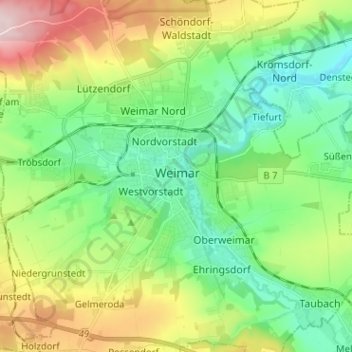
Name: Weimar topographic map, elevation, terrain.
Location: Weimar, Thüringen, 99423, Deutschland (50.94028 11.28909 51.02028 11.36909)
Average elevation: 925 ft
Minimum elevation: 623 ft
Maximum elevation: 1,535 ft
Make a donation
Gear up for your next adventure:
As an Amazon Associate, this site earns from qualifying purchases at no extra cost to you.
Other topographic maps
Click on a map to view its topography, its elevation and its terrain.
Ilmpark
Deutschland > Thüringen > Weimar
Bemerkenswert ist auch das Haus Ithaka, das 1907 für den Dichter Ernst von Wildenbruch vom Architekten Paul Schultze-Naumburg auf einer Anhöhe oberhalb des Osthanges erbaut wurde, welches einen Blick auf den Park hatte. Diese Blickbeziehung ist jedoch ab 1997 unterhalb der Villa durch Investorenarchitektur…
Average elevation: 797 ft
Make a donation
Gear up for your next adventure:
As an Amazon Associate, this site earns from qualifying purchases at no extra cost to you.