
Make a donation
Gear up for your next adventure:
As an Amazon Associate, this site earns from qualifying purchases at no extra cost to you.
Isérables topographic map
Click on the map to display elevation.
Make a donation
Gear up for your next adventure:
As an Amazon Associate, this site earns from qualifying purchases at no extra cost to you.
About this map
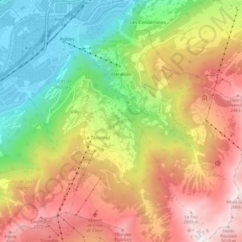
Name: Isérables topographic map, elevation, terrain.
Location: Isérables, Martigny, Wallis, 1914, Switzerland (46.11528 7.23014 46.18258 7.29556)
Average elevation: 4,934 ft
Minimum elevation: 1,522 ft
Maximum elevation: 8,888 ft
Make a donation
Gear up for your next adventure:
As an Amazon Associate, this site earns from qualifying purchases at no extra cost to you.
Other topographic maps
Click on a map to view its topography, its elevation and its terrain.
Col de la Forclaz
Switzerland > Wallis > Martigny > Trient > Col de la Forclaz
Average elevation: 5,371 ft
Make a donation
Gear up for your next adventure:
As an Amazon Associate, this site earns from qualifying purchases at no extra cost to you.