Geolocate

Manthali topographic map

Click on the map to display elevation.

About this map

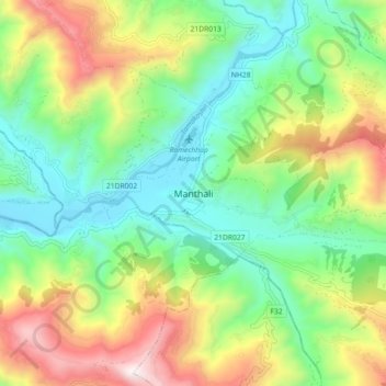
Name: Manthali topographic map, elevation, terrain.

Location: Manthali, Ramechhap, Bagmati Province, Nepal (27.34162 86.02076 27.42162 86.10076)

Average elevation: 2,933 ft

Minimum elevation: 1,552 ft

Maximum elevation: 5,420 ft

Other topographic maps

Click on a map to view its topography, its elevation and its terrain.

Manthali

Nepal > Bagmati Province > Ramechhap

Average elevation: 3,625 ft

Doramba

Nepal > Bagmati Province > Ramechhap

Average elevation: 5,988 ft

Gear up for your next adventure:

🪶Trail Camera - Capture wildlife on your hikes
🧭GPS Watch Accessories - Bands and chargers for GPS watches
🦺Reflective Outdoor Gear - Safety gear for low‑light conditions
📶Vehicle Signal Boosters - Improve reception in rural areas while driving to trailheads
🔦Powerful Headlamps - Ultra-bright hands-free lighting for night navigation

As an Amazon Associate, this site earns from qualifying purchases at no extra cost to you.