

Tseax Cone topographic map
Click on the map to display elevation.
Tseax Cone
Tseax Cone (/ˈsiːæks/ SEE-aks) is a small volcano in the Nass Ranges of the Hazelton Mountains in northwestern British Columbia, Canada. It has an elevation of 609 metres (1,998 feet) and lies within an east–west valley through which a tributary of the Tseax River flows. The volcano consists of two nested structures and was the source of four lava flows that descended into neighbouring valleys. A secondary eruptive centre lies just north of Tseax Cone on the opposite side of Melita Lake. It probably formed simultaneously with Tseax Cone, but the timing of volcanism at the two eruptive centres is not precisely known; both were formed by volcanic activity sometime in the last 800 years.
About this map
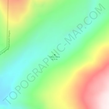
Name: Tseax Cone topographic map, elevation, terrain.
Average elevation: 2,372 ft
Minimum elevation: 1,424 ft
Maximum elevation: 3,970 ft
Other topographic maps
Click on a map to view its topography, its elevation and its terrain.
Munro Lake
Canada > British Columbia > Regional District of Kitimat-Stikine > Area A (Nass Valley/Bell Irving)
Average elevation: 2,320 ft

Tom Mackay Lake
Canada > British Columbia > Regional District of Kitimat-Stikine > Area A (Nass Valley/Bell Irving)
Average elevation: 3,734 ft

Border Lake Provincial Park
Canada > British Columbia > Regional District of Kitimat-Stikine > Area A (Nass Valley/Bell Irving)
Average elevation: 1,010 ft
Sandal Lake
Canada > British Columbia > Regional District of Kitimat-Stikine > Area A (Nass Valley/Bell Irving)
Average elevation: 1,243 ft

Derrick Lake
Canada > British Columbia > Regional District of Kitimat-Stikine > Area A (Nass Valley/Bell Irving)
Average elevation: 1,562 ft