
Make a donation
Gear up for your next adventure:
As an Amazon Associate, this site earns from qualifying purchases at no extra cost to you.
Northampton topographic map
Click on the map to display elevation.
Make a donation
Gear up for your next adventure:
As an Amazon Associate, this site earns from qualifying purchases at no extra cost to you.
Northampton
According to the U.S. Census Bureau, the borough has a total area of 2.7 square miles (7.0 km2); 2.6 square miles (6.7 km2) is land and 0.1 square miles (0.26 km2) (3.70%), water. Northampton's elevation is 370 feet (110 m) above sea level.
Make a donation
Gear up for your next adventure:
As an Amazon Associate, this site earns from qualifying purchases at no extra cost to you.
About this map
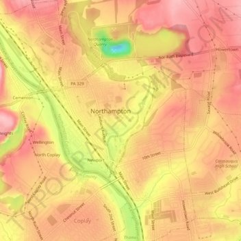
Name: Northampton topographic map, elevation, terrain.
Location: Northampton, Northampton County, Pennsylvania, United States (40.66687 -75.51586 40.70441 -75.47217)
Average elevation: 371 ft
Minimum elevation: 36 ft
Maximum elevation: 522 ft
Northampton County trails, hiking, mountain biking, running and outdoor activities
Make a donation
Gear up for your next adventure:
As an Amazon Associate, this site earns from qualifying purchases at no extra cost to you.
Other topographic maps
Click on a map to view its topography, its elevation and its terrain.
Weiders Crossing
United States > Pennsylvania > Northampton County > Lehigh Township
Average elevation: 715 ft
Pennsville
United States > Pennsylvania > Northampton County > Lehigh Township
Average elevation: 627 ft
Raubsville
United States > Pennsylvania > Northampton County > Williams Township
Average elevation: 335 ft
Make a donation
Gear up for your next adventure:
As an Amazon Associate, this site earns from qualifying purchases at no extra cost to you.
Slateford
United States > Pennsylvania > Northampton County > Upper Mount Bethel Township
Average elevation: 630 ft
Kesslersville
United States > Pennsylvania > Northampton County > Plainfield Township
Average elevation: 581 ft
Make a donation
Gear up for your next adventure:
As an Amazon Associate, this site earns from qualifying purchases at no extra cost to you.
Stouts
United States > Pennsylvania > Northampton County > Williams Township > Stouts
Average elevation: 541 ft
Green Pond
United States > Pennsylvania > Northampton County > Bethlehem Township
Average elevation: 407 ft
Browntown
United States > Pennsylvania > Northampton County > Glendon > Browntown
Average elevation: 374 ft
Make a donation
Gear up for your next adventure:
As an Amazon Associate, this site earns from qualifying purchases at no extra cost to you.
Butztown
United States > Pennsylvania > Northampton County > Bethlehem Township
Average elevation: 361 ft