Geolocate

Whitewater topographic map

Click on the map to display elevation.

About this map

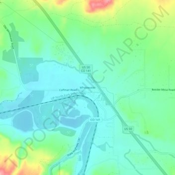
Name: Whitewater topographic map, elevation, terrain.

Location: Whitewater, Mesa County, Colorado, United States (38.97109 -108.47342 39.01109 -108.43342)

Average elevation: 4,724 ft

Minimum elevation: 4,619 ft

Maximum elevation: 5,023 ft

Mesa County trails, hiking, mountain biking, running and outdoor activities

Other topographic maps

Click on a map to view its topography, its elevation and its terrain.

Powderhorn Ski Area

United States > Colorado > Mesa County

Average elevation: 9,072 ft

De Beque

United States > Colorado > Mesa County

Average elevation: 5,240 ft

Clifton

United States > Colorado > Mesa County

Average elevation: 4,695 ft

Gear up for your next adventure:

🕶️GPS Smartphone Mount - Secure mount for phone navigation
🛡️Bear Spray Outdoor - Protection in bear country hikes
🔋Solar Power Banks - Keep your GPS and phone charged in remote wilderness areas
🏔️Mountain Trail Maps - High‑detail maps for popular peaks
🥾Hiking Shoes - Durable and comfortable shoes for trail hiking

As an Amazon Associate, this site earns from qualifying purchases at no extra cost to you.