Geolocate

Llanfachreth topographic map

Click on the map to display elevation.

About this map

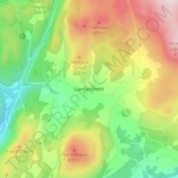
Name: Llanfachreth topographic map, elevation, terrain.

Location: Llanfachreth, Gwynedd, Wales, LL40 2ED, United Kingdom (52.76563 -3.86898 52.80563 -3.82898)

Average elevation: 755 ft

Minimum elevation: 30 ft

Maximum elevation: 1,719 ft

Other topographic maps

Click on a map to view its topography, its elevation and its terrain.

Llyn y Dywarchen

United Kingdom > Wales > Gwynedd > Rhyd-ddu

Average elevation: 856 ft

Betws Garmon

United Kingdom > Wales > Gwynedd

Average elevation: 935 ft

Llyn Cau

United Kingdom > Wales > Gwynedd

Average elevation: 1,821 ft

Gear up for your next adventure:

🔪Outdoor Multitools - Essential survival tools for gear repair and field use
🚪Portable Camp Chair - Foldable chair for comfort at camp
😴Insulated Sleeping Pads - Compact and warm pads for high-elevation camping
🪄Magnetic Compass - Accurate compass for navigation
🗺️NatGeo Topo Maps - High-quality waterproof printed topographic maps of US Parks

As an Amazon Associate, this site earns from qualifying purchases at no extra cost to you.