
Hainesville topographic map
Click on the map to display elevation.
About this map
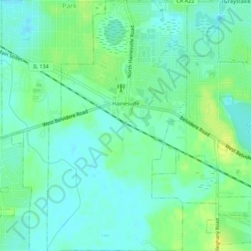
Name: Hainesville topographic map, elevation, terrain.
Location: Hainesville, Lake County, Illinois, United States (42.32780 -88.08027 42.35703 -88.05819)
Average elevation: 794 ft
Minimum elevation: 771 ft
Maximum elevation: 830 ft
Lake County trails, hiking, mountain biking, running and outdoor activities
Other topographic maps
Click on a map to view its topography, its elevation and its terrain.
Illinois Beach State Park
United States > Illinois > Lake County
The park is located in the 12 mile long Zion Beach Ridge Plain. The Zion Beach Ridge Plain is 3,700 years old and composed of curvilinear ridge-and-swale topography. The beach ridges support black oak savanna habitat, while wetlands dominate the swales. The Zion Beach Ridge Plain has been migrating south…
Average elevation: 584 ft
Lake Naomi
United States > Illinois > Lake County > Hawthorn Woods > White Birch Lakes
Average elevation: 856 ft