
Make a donation
Gear up for your next adventure:
As an Amazon Associate, this site earns from qualifying purchases at no extra cost to you.
Aksay Kazakh Autonomous County topographic map
Click on the map to display elevation.
Make a donation
Gear up for your next adventure:
As an Amazon Associate, this site earns from qualifying purchases at no extra cost to you.
Aksay Kazakh Autonomous County
The county lies on the northern edge of the Tibetan Plateau and has an average elevation of about 3,200 meters.
Make a donation
Gear up for your next adventure:
As an Amazon Associate, this site earns from qualifying purchases at no extra cost to you.
About this map
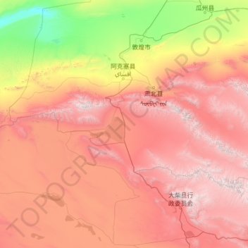
Name: Aksay Kazakh Autonomous County topographic map, elevation, terrain.
Location: Aksay Kazakh Autonomous County, Jiuquan, Gansu, 736400, China (38.14495 92.33865 39.86930 96.68947)
Average elevation: 8,730 ft
Minimum elevation: 2,657 ft
Maximum elevation: 18,711 ft
Make a donation
Gear up for your next adventure:
As an Amazon Associate, this site earns from qualifying purchases at no extra cost to you.
Other topographic maps
Click on a map to view its topography, its elevation and its terrain.
Make a donation
Gear up for your next adventure:
As an Amazon Associate, this site earns from qualifying purchases at no extra cost to you.