Geolocate

Aberdeen topographic map

Click on the map to display elevation.

About this map

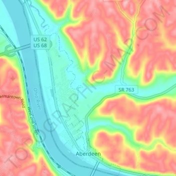
Name: Aberdeen topographic map, elevation, terrain.

Location: Aberdeen, Brown County, Ohio, 45101, United States (38.64957 -83.78396 38.69700 -83.74985)

Average elevation: 692 ft

Minimum elevation: 482 ft

Maximum elevation: 932 ft

Brown County trails, hiking, mountain biking, running and outdoor activities

Other topographic maps

Click on a map to view its topography, its elevation and its terrain.

Decatur

United States > Ohio > Brown County

Average elevation: 889 ft

Lake Lorelei

United States > Ohio > Brown County > Vera Cruz

Average elevation: 945 ft

Lake Waynoka

United States > Ohio > Brown County

Average elevation: 1,020 ft

Chasetown

United States > Ohio > Brown County

Average elevation: 945 ft

Vera Cruz

United States > Ohio > Brown County

Average elevation: 928 ft

Gear up for your next adventure:

🗺️Topographic Maps - Detailed topo maps for hiking, exploring and outdoor navigation
🛰️Satellite Messengers - Emergency SOS and two-way messaging for off-grid adventures
📱Heavy-Duty Phone Cases - Drop-proof and waterproof protection for outdoor navigation
🔥Camping Stove - Portable stove for camping and backcountry cooking
🥩Freeze-Dried Meals - Nutritious and lightweight food for remote expeditions

As an Amazon Associate, this site earns from qualifying purchases at no extra cost to you.