Geolocate

Balanga topographic map

Click on the map to display elevation.

About this map

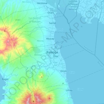
Name: Balanga topographic map, elevation, terrain.

Location: Balanga, Bataan, Central Luzon, 2100, Philippines (14.51957 120.38097 14.83957 120.70097)

Average elevation: 440 ft

Minimum elevation: -10 ft

Maximum elevation: 4,413 ft

Other topographic maps

Click on a map to view its topography, its elevation and its terrain.

Cataning

Philippines > Bataan > Balanga

Average elevation: 36 ft

Gear up for your next adventure:

🌐World Map Poster - Decorative world maps with topographic info
🌲Outdoor Survival Books - Best books on survival skills
🔦Compact Flashlight - Reliable flashlight for emergencies
🔦LED Headlamp - Bright and durable LED headlamp for night navigation
🎒Hydration Pack - Hands‑free water reservoir for long hikes

As an Amazon Associate, this site earns from qualifying purchases at no extra cost to you.