
Junín topographic map
Click on the map to display elevation.
Junín
The region has a very heterogeneous topography. The western range located near the border with the Lima Region, has snowy and ice-covered peaks. On the east, there are high glacier valleys which end up in high plateaus (Altiplano). Among them is the Junín Plateau that is located between the cities of La Oroya and Cerro de Pasco.
About this map
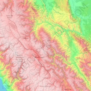
Name: Junín topographic map, elevation, terrain.
Location: Junín, Peru (-12.68372 -76.51923 -10.65340 -73.35513)
Average elevation: 8,717 ft
Minimum elevation: 0 ft
Maximum elevation: 18,346 ft
Other topographic maps
Click on a map to view its topography, its elevation and its terrain.
La Rinconada
The town has gained notoriety for its extreme living conditions that include its high rates of altitude sickness, pollution, poverty, murder, and sex trafficking, and as a result has sometimes been referred to as in Spanish as "ciudad sin ley del Perú," which means "lawless city of Peru."
Average elevation: 16,152 ft
Vinicunca
Vinicunca, or Winikunka, also called Montaña de Siete Colores (literally: Mountain of seven colors), Montaña de Colores (Mountain of colors) or Montaña Arcoíris (Rainbow Mountain), is a mountain in the Andes of Peru with an altitude of 5,200 metres (17,100 ft) above sea level. It is located on the road to…
Average elevation: 15,991 ft
Lima
Relative humidity is always very high, particularly in the mornings. High humidity produces brief morning fog in the early summer and a usually persistent low cloud deck during the winter (generally develops in late May and persists until mid-November or even early December). The predominantly onshore flow…
Average elevation: 663 ft