Geolocate

Nelson topographic map

Click on the map to display elevation.

About this map

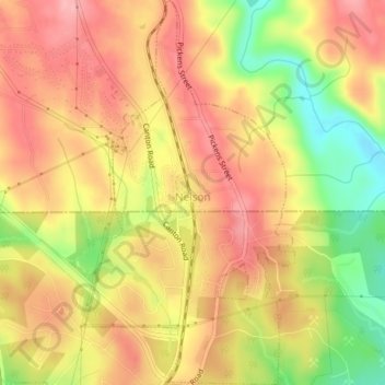
Name: Nelson topographic map, elevation, terrain.

Location: Nelson, Pickens County, Georgia, 30151, United States (34.36606 -84.38222 34.39872 -84.36054)

Average elevation: 1,227 ft

Minimum elevation: 965 ft

Maximum elevation: 1,394 ft

Pickens County trails, hiking, mountain biking, running and outdoor activities

Other topographic maps

Click on a map to view its topography, its elevation and its terrain.

Ludville

United States > Georgia > Pickens County

Average elevation: 1,194 ft

Cagle

United States > Georgia > Pickens County

Average elevation: 1,184 ft

Talking Rock

United States > Georgia > Pickens County > Talking Rock

Average elevation: 1,247 ft

Cox Mountain

United States > Georgia > Pickens County

Average elevation: 1,634 ft

Sharp Mountain

United States > Georgia > Pickens County

Average elevation: 1,693 ft

Jasper City Park

United States > Georgia > Pickens County > Jasper

Average elevation: 1,398 ft

Tate

United States > Georgia > Pickens County

Average elevation: 1,207 ft

Gear up for your next adventure:

🔪Outdoor Multitools - Essential survival tools for gear repair and field use
🛏️Cold Weather Sleeping Bag - Warm sleeping bag for cold conditions
🦶Hiking Gaiters - Keep debris and water out of your boots
💧Water Purification System - Clean water on the trail with reliable purifiers
📡Handheld GPS Device - Reliable handheld GPS for outdoor navigation

As an Amazon Associate, this site earns from qualifying purchases at no extra cost to you.