
Lake Country topographic map
Click on the map to display elevation.
About this map
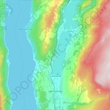
Name: Lake Country topographic map, elevation, terrain.
Average elevation: 2,133 ft
Minimum elevation: 1,106 ft
Maximum elevation: 4,921 ft
Other topographic maps
Click on a map to view its topography, its elevation and its terrain.
Sonora Park
Canada > British Columbia > Regional District of Central Okanagan > Kelowna
Average elevation: 1,371 ft
Ellison
Canada > British Columbia > Regional District of Central Okanagan > East Central Okanagan Electoral Area > Ellison
Average elevation: 1,640 ft
West Kelowna
Canada > British Columbia > Regional District of Central Okanagan > West Kelowna
Average elevation: 2,858 ft
Kangaroo
Canada > British Columbia > Regional District of Central Okanagan > East Central Okanagan Electoral Area
Average elevation: 1,503 ft