Beloit topographic map
Interactive map
Click on the map to display elevation.
About this map
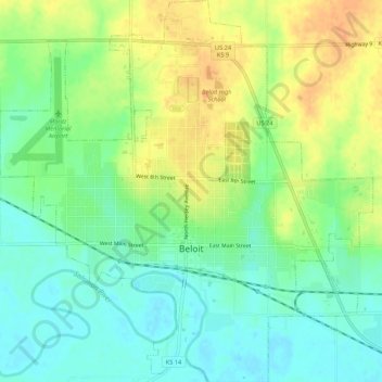
Name: Beloit topographic map, elevation, terrain.
Location: Beloit, Mitchell County, Kansas, United States (39.44419 -98.13515 39.48558 -98.08276)
Average elevation: 1,417 ft
Minimum elevation: 1,362 ft
Maximum elevation: 1,486 ft
Other topographic maps
Click on a map to view its topography, its elevation and its terrain.
Asherville
United States > Kansas > Mitchell County
Asherville, Mitchell County, Kansas, 67478, United States
Average elevation: 1,352 ft
Victor
United States > Kansas > Mitchell County
Victor, Mitchell County, Kansas, United States
Average elevation: 1,509 ft
Simpson
United States > Kansas > Mitchell County
Simpson, Mitchell County, Kansas, 67478, United States
Average elevation: 1,335 ft
Hunter
United States > Kansas > Mitchell County
Hunter, Mitchell County, Kansas, United States
Average elevation: 1,624 ft
Glen Elder
United States > Kansas > Mitchell County
Glen Elder, Mitchell County, Kansas, 67446, United States
Average elevation: 1,447 ft