
Make a donation
Gear up for your next adventure:
As an Amazon Associate, this site earns from qualifying purchases at no extra cost to you.
Benjamin topographic map
Click on the map to display elevation.
Make a donation
Gear up for your next adventure:
As an Amazon Associate, this site earns from qualifying purchases at no extra cost to you.
About this map
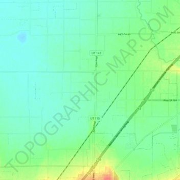
Name: Benjamin topographic map, elevation, terrain.
Location: Benjamin, Utah County, Utah, United States (40.06318 -111.79285 40.11640 -111.68820)
Average elevation: 4,528 ft
Minimum elevation: 4,482 ft
Maximum elevation: 4,652 ft
Utah County trails, hiking, mountain biking, running and outdoor activities
Make a donation
Gear up for your next adventure:
As an Amazon Associate, this site earns from qualifying purchases at no extra cost to you.
Other topographic maps
Click on a map to view its topography, its elevation and its terrain.
Make a donation
Gear up for your next adventure:
As an Amazon Associate, this site earns from qualifying purchases at no extra cost to you.
Make a donation
Gear up for your next adventure:
As an Amazon Associate, this site earns from qualifying purchases at no extra cost to you.
Saratoga Springs Park
United States > Utah > Utah County > Saratoga Springs > Saratoga Resort
Average elevation: 4,511 ft