
门限石乡 topographic map
Interactive map
Click on the map to display elevation.
About this map
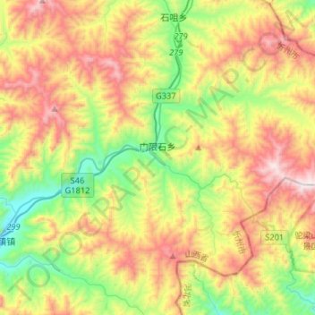
Name: 门限石乡 topographic map, elevation, terrain.
Location: 门限石乡, 五台县, 忻州市, 山西省, 中国 (38.69906 113.58779 38.85204 113.84916)
Average elevation: 5,030 ft
Minimum elevation: 3,297 ft
Maximum elevation: 7,415 ft
Other topographic maps
Click on a map to view its topography, its elevation and its terrain.