
Make a donation
Gear up for your next adventure:
As an Amazon Associate, this site earns from qualifying purchases at no extra cost to you.
Flat Rock topographic map
Click on the map to display elevation.
Make a donation
Gear up for your next adventure:
As an Amazon Associate, this site earns from qualifying purchases at no extra cost to you.
About this map
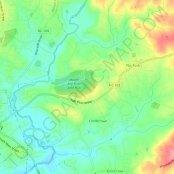
Name: Flat Rock topographic map, elevation, terrain.
Location: Flat Rock, Surry County, North Carolina, United States (36.49311 -80.60101 36.52242 -80.55549)
Average elevation: 1,093 ft
Minimum elevation: 981 ft
Maximum elevation: 1,283 ft
Surry County trails, hiking, mountain biking, running and outdoor activities
Make a donation
Gear up for your next adventure:
As an Amazon Associate, this site earns from qualifying purchases at no extra cost to you.
Other topographic maps
Click on a map to view its topography, its elevation and its terrain.
Make a donation
Gear up for your next adventure:
As an Amazon Associate, this site earns from qualifying purchases at no extra cost to you.
Mount Airy
United States > North Carolina > Surry County > Mount Airy > Mount Airy
Average elevation: 1,109 ft