
Brexton topographic map
Click on the map to display elevation.
About this map
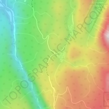
Name: Brexton topographic map, elevation, terrain.
Average elevation: 3,199 ft
Minimum elevation: 2,165 ft
Maximum elevation: 4,459 ft
Other topographic maps
Click on a map to view its topography, its elevation and its terrain.
Spruce Lake
Canada > British Columbia > Squamish-Lillooet Regional District > Area A (Upper Bridge River Valley)
Average elevation: 5,538 ft
Carpenter Lake
Canada > British Columbia > Squamish-Lillooet Regional District > Area A (Upper Bridge River Valley)
Average elevation: 5,223 ft
Gun Creek
Canada > British Columbia > Squamish-Lillooet Regional District > Area A (Upper Bridge River Valley)
Average elevation: 4,505 ft
Bridge Glacier
Canada > British Columbia > Squamish-Lillooet Regional District > Area A (Upper Bridge River Valley)
Average elevation: 7,457 ft
Little Big Horn
Canada > British Columbia > Squamish-Lillooet Regional District > Area A (Upper Bridge River Valley)
Average elevation: 6,516 ft