Geolocate

Channahon topographic map

Click on the map to display elevation.

About this map
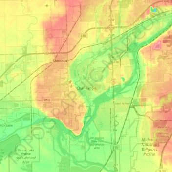
Name: Channahon topographic map, elevation, terrain.

Location: Channahon, Channahon Township, Will County, Illinois, 60410, United States (41.37640 -88.38716 41.48654 -88.17191)

Average elevation: 561 ft

Minimum elevation: 433 ft

Maximum elevation: 692 ft

Will County trails, hiking, mountain biking, running and outdoor activities

Other topographic maps

Click on a map to view its topography, its elevation and its terrain.

Drummond

United States > Illinois > Will County

Average elevation: 548 ft

Marley

United States > Illinois > Will County

Average elevation: 702 ft

Welco Corners

United States > Illinois > Will County > Bolingbrook

Average elevation: 719 ft

Puddle Pond

United States > Illinois > Will County > Plainfield

Average elevation: 614 ft

Arbury Hills

United States > Illinois > Will County

Average elevation: 709 ft

Gear up for your next adventure:

🧢Sun Protection Hats - Wide-brimmed and UPF-rated hats for high-altitude sun safety
🌐World Map Poster - Decorative world maps with topographic info
🎁Geography Themed Gifts - Unique gift ideas for map lovers and geography enthusiasts
📶Vehicle Signal Boosters - Improve reception in rural areas while driving to trailheads
🕶️Glacier Sunglasses - Side shields to protect eyes from high-altitude snow glare

As an Amazon Associate, this site earns from qualifying purchases at no extra cost to you.