Geolocate

Medway topographic map

Click on the map to display elevation.

About this map

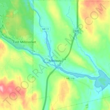
Name: Medway topographic map, elevation, terrain.

Location: Medway, Penobscot County, Maine, 04460, United States (45.55940 -68.56290 45.66929 -68.42686)

Average elevation: 394 ft

Minimum elevation: 230 ft

Maximum elevation: 761 ft

Penobscot County trails, hiking, mountain biking, running and outdoor activities

Other topographic maps

Click on a map to view its topography, its elevation and its terrain.

Lincoln

United States > Maine > Penobscot County > Lincoln

Average elevation: 272 ft

Houston Island

United States > Maine > Penobscot County > Winn

Average elevation: 243 ft

Carroll

United States > Maine > Penobscot County

Average elevation: 778 ft

Fairmont Park

United States > Maine > Penobscot County > Bangor

Average elevation: 148 ft

Meadow Brook

United States > Maine > Penobscot County

Average elevation: 325 ft

Gear up for your next adventure:

🥾Women's Hiking Boots - Top-rated trail boots with ankle support and superior grip
🪶LED Camping Lantern - Bright lantern for camp lighting
📦Dry Bags Set - Waterproof storage for electronics and clothes
📷Action Camera - Capture your outdoor adventures in HD
🗃️Trail First Aid Kit - Essential kit for outdoor injuries and emergencies

As an Amazon Associate, this site earns from qualifying purchases at no extra cost to you.