Geolocate

Buford topographic map

Click on the map to display elevation.
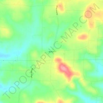
About this map

Name: Buford topographic map, elevation, terrain.

Location: Buford, Baxter County, Arkansas, United States (36.22562 -92.44849 36.26562 -92.40849)

Average elevation: 738 ft

Minimum elevation: 597 ft

Maximum elevation: 955 ft

Baxter County trails, hiking, mountain biking, running and outdoor activities

Other topographic maps

Click on a map to view its topography, its elevation and its terrain.

Gassville

United States > Arkansas > Baxter County

Average elevation: 656 ft

Salesville

United States > Arkansas > Baxter County

Average elevation: 558 ft

Big Flat

United States > Arkansas > Baxter County

Average elevation: 1,161 ft

Norfork Lake

United States > Arkansas > Baxter County

Average elevation: 741 ft

Briarcliff

United States > Arkansas > Baxter County

Average elevation: 774 ft

Gear up for your next adventure:

🩹Survival Bandages - High‑quality bandages for emergencies
🪵Folding Camp Saw - Compact saw for wood and campsite work
GPS Sports Watch - GPS watch for running, hiking and training
💧Water Purification System - Clean water on the trail with reliable purifiers
🌡️Handheld Weather Meters - Measure wind, temp, and pressure for safe mountain travel

As an Amazon Associate, this site earns from qualifying purchases at no extra cost to you.