
Make a donation
Gear up for your next adventure:
As an Amazon Associate, this site earns from qualifying purchases at no extra cost to you.
Whitman Lake topographic map
Click on the map to display elevation.
Make a donation
Gear up for your next adventure:
As an Amazon Associate, this site earns from qualifying purchases at no extra cost to you.
About this map
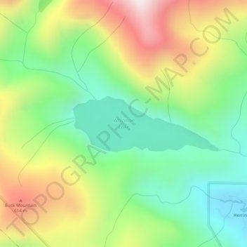
Name: Whitman Lake topographic map, elevation, terrain.
Location: Whitman Lake, Ketchikan Gateway, Alaska, United States (55.33292 -131.56000 55.33902 -131.53188)
Average elevation: 1,027 ft
Minimum elevation: 0 ft
Maximum elevation: 2,575 ft
Ketchikan Gateway trails, hiking, mountain biking, running and outdoor activities
Make a donation
Gear up for your next adventure:
As an Amazon Associate, this site earns from qualifying purchases at no extra cost to you.
Other topographic maps
Click on a map to view its topography, its elevation and its terrain.
Make a donation
Gear up for your next adventure:
As an Amazon Associate, this site earns from qualifying purchases at no extra cost to you.