Geolocate

Saxman topographic map

Click on the map to display elevation.

About this map

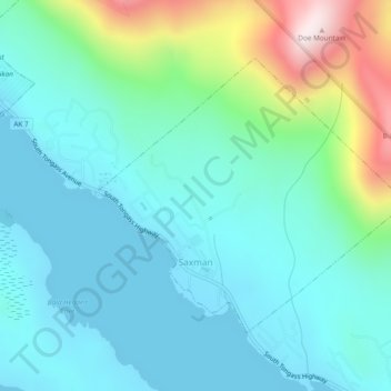
Name: Saxman topographic map, elevation, terrain.

Location: Saxman, Ketchikan Gateway, Alaska, United States (55.31343 -131.60809 55.33243 -131.57021)

Average elevation: 456 ft

Minimum elevation: 0 ft

Maximum elevation: 2,126 ft

Ketchikan Gateway trails, hiking, mountain biking, running and outdoor activities

Other topographic maps

Click on a map to view its topography, its elevation and its terrain.

Juno Mountain

United States > Alaska > Ketchikan Gateway

Average elevation: 1,437 ft

Herring Cove

United States > Alaska > Ketchikan Gateway

Average elevation: 515 ft

Whitman Lake

United States > Alaska > Ketchikan Gateway

Average elevation: 1,027 ft

Marten River

United States > Alaska > Ketchikan Gateway

Average elevation: 679 ft

Mud Bay

United States > Alaska > Ketchikan Gateway

Average elevation: 377 ft

Gear up for your next adventure:

🛠️Outdoor Gear Repair Kit - Essential tools to fix gear on the trail
🎁Geography Themed Gifts - Unique gift ideas for map lovers and geography enthusiasts
🖼️Topo Map Wall Art - Decorative topographic prints of famous peaks and regions
🦶Carbon Trekking Poles - Reduce knee impact on steep descents with ultra-light poles
🔭Compact Binoculars - HD vision for scouting terrain and identifying distant landmarks

As an Amazon Associate, this site earns from qualifying purchases at no extra cost to you.