Geolocate

Mount Airy topographic map

Click on the map to display elevation.

About this map

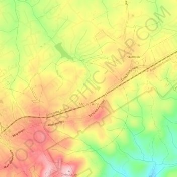
Name: Mount Airy topographic map, elevation, terrain.

Location: Mount Airy, Habersham County, Georgia, United States (34.50699 -83.51872 34.53783 -83.46669)

Average elevation: 1,453 ft

Minimum elevation: 1,040 ft

Maximum elevation: 1,785 ft

Habersham County trails, hiking, mountain biking, running and outdoor activities

Other topographic maps

Click on a map to view its topography, its elevation and its terrain.

Aerial

United States > Georgia > Habersham County

Average elevation: 1,476 ft

Pardue Mill

United States > Georgia > Habersham County

Average elevation: 1,355 ft

Gear up for your next adventure:

🧯Emergency Survival Kit - All‑in‑one survival essentials for the backcountry
🧭Hiking Compass - Precision compass for reliable navigation in the wilderness
🗃️Trail First Aid Kit - Essential kit for outdoor injuries and emergencies
🥩Freeze-Dried Meals - Nutritious and lightweight food for remote expeditions
Backpacking Tents - Weight-optimized shelters for multi-day topographic surveys

As an Amazon Associate, this site earns from qualifying purchases at no extra cost to you.