Geolocate

Three Forks topographic map

Click on the map to display elevation.

About this map

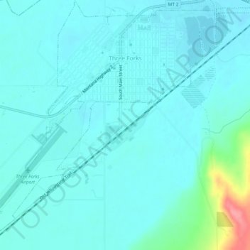
Name: Three Forks topographic map, elevation, terrain.

Location: Three Forks, Gallatin County, Montana, 59752, United States (45.86781 -111.58054 45.90006 -111.53467)

Average elevation: 4,098 ft

Minimum elevation: 4,055 ft

Maximum elevation: 4,354 ft

Gallatin County trails, hiking, mountain biking, running and outdoor activities

Other topographic maps

Click on a map to view its topography, its elevation and its terrain.

Gallatin Gateway

United States > Montana > Gallatin County

Gallatin Gateway is a census-designated place (CDP) in Gallatin County, Montana, United States. As of the 2020 census, Gallatin Gateway had a population of 967. Elevation is 4,953 ft (1,510 m).

Average elevation: 4,984 ft

Chestnut

United States > Montana > Gallatin County

Average elevation: 5,748 ft

Blacktail Mountain

United States > Montana > Gallatin County

Average elevation: 7,346 ft

Clarkston

United States > Montana > Gallatin County

Average elevation: 4,055 ft

Bozeman Beacon

United States > Montana > Gallatin County

Average elevation: 5,194 ft

Burke Park

United States > Montana > Gallatin County > Bozeman

Average elevation: 4,902 ft

Town Center

United States > Montana > Gallatin County > Big Sky

Average elevation: 6,404 ft

Logan

United States > Montana > Gallatin County

Average elevation: 4,245 ft

Bozeman

United States > Montana > Gallatin County > Bozeman

Bozeman is located at an elevation of 4,820 feet (1,470 m). The Bridger Mountains are to the north-northeast, the Tobacco Root Mountains to the west-south-west, the Big Belt Mountains and Horseshoe Hills to the northwest, the Hyalite Peaks of the northern Gallatin Range to the south and the Spanish Peaks of…

Average elevation: 5,509 ft

Gear up for your next adventure:

🧦Merino Wool Socks - Moisture-wicking, blister-preventing socks for long treks
🔦LED Headlamp - Bright and durable LED headlamp for night navigation
🧭GPS Watch Accessories - Bands and chargers for GPS watches
🔥Camping Stove - Portable stove for camping and backcountry cooking
🗺️NatGeo Topo Maps - High-quality waterproof printed topographic maps of US Parks

As an Amazon Associate, this site earns from qualifying purchases at no extra cost to you.