
Make a donation
Gear up for your next adventure:
As an Amazon Associate, this site earns from qualifying purchases at no extra cost to you.
Cipreses topographic map
Click on the map to display elevation.
Make a donation
Gear up for your next adventure:
As an Amazon Associate, this site earns from qualifying purchases at no extra cost to you.
About this map
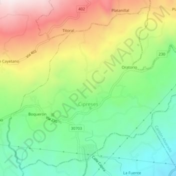
Name: Cipreses topographic map, elevation, terrain.
Location: Cipreses, Oreamuno, Cartago Province, 30704, Costa Rica (9.87682 -83.86133 9.91208 -83.82251)
Average elevation: 5,823 ft
Minimum elevation: 4,875 ft
Maximum elevation: 7,185 ft
Make a donation
Gear up for your next adventure:
As an Amazon Associate, this site earns from qualifying purchases at no extra cost to you.
Other topographic maps
Click on a map to view its topography, its elevation and its terrain.
Irazú Volcano
Costa Rica > Oreamuno > Santa Rosa
The Irazú volcano is a complex volcanic shield. It is the highest active volcano in Costa Rica, and has an area of 500 km2 (190 sq mi). It has an irregular subconic shape, and temperatures at its summit vary between 3 and 17 °C (37 and 63 °F), with a record low of −3 °C(26.6 °F) and a record high of…
Average elevation: 10,217 ft