
Make a donation
Gear up for your next adventure:
As an Amazon Associate, this site earns from qualifying purchases at no extra cost to you.
Braach topographic map
Click on the map to display elevation.
Make a donation
Gear up for your next adventure:
As an Amazon Associate, this site earns from qualifying purchases at no extra cost to you.
About this map
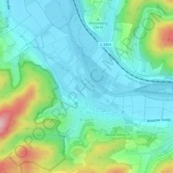
Name: Braach topographic map, elevation, terrain.
Average elevation: 764 ft
Minimum elevation: 591 ft
Maximum elevation: 1,273 ft
Make a donation
Gear up for your next adventure:
As an Amazon Associate, this site earns from qualifying purchases at no extra cost to you.
Other topographic maps
Click on a map to view its topography, its elevation and its terrain.
Bad Hersfeld
Deutschland > Hessen > Landkreis Hersfeld-Rotenburg
Der größte Bereich der offen zu Tage tretenden Gesteinsschichten gehört in das Erdzeitalter des Mittleren Buntsandsteins (der Buntsandstein ist die Untere Trias). Die Höhenzüge rund um die Stadt werden daher im Wesentlichen durch die Formation der Germanischen Trias gebildet. Aus dieser Formation stammen…
Average elevation: 922 ft
Make a donation
Gear up for your next adventure:
As an Amazon Associate, this site earns from qualifying purchases at no extra cost to you.
Knüllgebirge
Deutschland > Hessen > Landkreis Hersfeld-Rotenburg
Das flachwelligere und stark landwirtschaftlich genutzte Homberger Hochland (356.3) schließt sich nördlich der Efze bei Homberg an den höheren Knüll an. Es reicht westlich bis kurz vor die Schwalm bzw. – ab deren Mündung – an die Eder.
Average elevation: 1,093 ft
Make a donation
Gear up for your next adventure:
As an Amazon Associate, this site earns from qualifying purchases at no extra cost to you.
Philippsthal (Werra)
Deutschland > Hessen > Landkreis Hersfeld-Rotenburg > Philippsthal (Werra)
Der tiefste Punkt liegt mit 212 m ü. NN in der Werraaue bei Harnrode. Der höchste Punkt liegt im Nordosten der Gemeindegemarkung auf etwa 445 m ü. NN Höhe, wo die Gemarkungsgrenzen von Philippsthal, Heringen und Vacha aufeinandertreffen.
Average elevation: 945 ft
Make a donation
Gear up for your next adventure:
As an Amazon Associate, this site earns from qualifying purchases at no extra cost to you.
Make a donation
Gear up for your next adventure:
As an Amazon Associate, this site earns from qualifying purchases at no extra cost to you.
Unterhaun
Deutschland > Hessen > Landkreis Hersfeld-Rotenburg
Der Ortsteil liegt im unteren Haunetal, beiderseits der Haune, bevor der Fluss etwa 3,5 Kilometer nördlich, in Bad Hersfeld in die Fulda fließt. Der alte Ortskern liegt auf der linken Flussseite, wo sich der Ort am westlichen Hang des Johannesberges und der vorgelagerte Anhöhe des Johannesberges, dem…
Average elevation: 899 ft
Make a donation
Gear up for your next adventure:
As an Amazon Associate, this site earns from qualifying purchases at no extra cost to you.
Make a donation
Gear up for your next adventure:
As an Amazon Associate, this site earns from qualifying purchases at no extra cost to you.
Hatterode
Deutschland > Hessen > Landkreis Hersfeld-Rotenburg
Nur wenige Kilometer nordwestlich des Ortes liegt die Burg Herzberg, die größte Höhenburg Hessens.
Average elevation: 1,033 ft
Make a donation
Gear up for your next adventure:
As an Amazon Associate, this site earns from qualifying purchases at no extra cost to you.
Niederellenbacher See
Deutschland > Hessen > Landkreis Hersfeld-Rotenburg > Niederellenbach
Average elevation: 705 ft
Make a donation
Gear up for your next adventure:
As an Amazon Associate, this site earns from qualifying purchases at no extra cost to you.
Blankenheim
Deutschland > Hessen > Landkreis Hersfeld-Rotenburg > Bebra > Blankenheim
Average elevation: 817 ft
Make a donation
Gear up for your next adventure:
As an Amazon Associate, this site earns from qualifying purchases at no extra cost to you.
Breitenbach am Herzberg
Deutschland > Hessen > Landkreis Hersfeld-Rotenburg
Average elevation: 1,037 ft