
Make a donation
Gear up for your next adventure:
As an Amazon Associate, this site earns from qualifying purchases at no extra cost to you.
Mount Lipsett topographic map
Click on the map to display elevation.
Make a donation
Gear up for your next adventure:
As an Amazon Associate, this site earns from qualifying purchases at no extra cost to you.
About this map
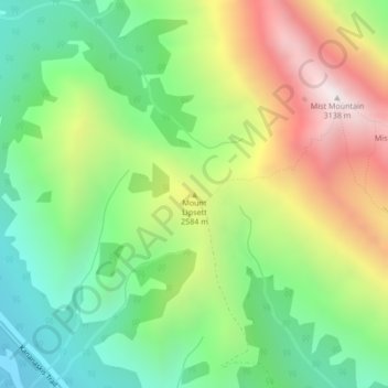
Name: Mount Lipsett topographic map, elevation, terrain.
Average elevation: 7,858 ft
Minimum elevation: 6,296 ft
Maximum elevation: 10,243 ft
Make a donation
Gear up for your next adventure:
As an Amazon Associate, this site earns from qualifying purchases at no extra cost to you.
Other topographic maps
Click on a map to view its topography, its elevation and its terrain.
Peter Lougheed Provincial Park
Canada > Alberta > Kananaskis Improvement District
Average elevation: 7,156 ft
Bow Valley Provincial Park
Canada > Alberta > Kananaskis Improvement District
Average elevation: 5,594 ft
West Bragg Creek Provincial Recreation Area
Canada > Alberta > Kananaskis Improvement District
Average elevation: 4,813 ft
Make a donation
Gear up for your next adventure:
As an Amazon Associate, this site earns from qualifying purchases at no extra cost to you.
Make a donation
Gear up for your next adventure:
As an Amazon Associate, this site earns from qualifying purchases at no extra cost to you.
Little Elbow Campground
Canada > Alberta > Kananaskis Improvement District
Average elevation: 5,502 ft