Geolocate

Lamabagar topographic map

Click on the map to display elevation.

About this map

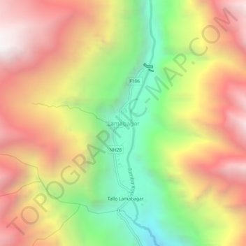
Name: Lamabagar topographic map, elevation, terrain.

Location: Lamabagar, Bigu, Dolakha, Bagamati Province, Nepal (27.89537 86.18883 27.93537 86.22883)

Average elevation: 8,904 ft

Minimum elevation: 5,453 ft

Maximum elevation: 12,139 ft

Other topographic maps

Click on a map to view its topography, its elevation and its terrain.

Gaurishankar

Nepal > Bagamati Province > Dolakha

Average elevation: 11,883 ft

Bigu

Nepal > Bagamati Province > Dolakha

Average elevation: 12,838 ft

Baiteshwor

Nepal > Bagamati Province > Dolakha

Average elevation: 5,610 ft

Bhimeshwor

Nepal > Bagamati Province > Dolakha

Average elevation: 6,535 ft

Tsho Rolpa Lake

Nepal > Bagamati Province > Dolakha

Tsho Rolpa (also Cho Rolpa) is one of the biggest glacial lakes in Nepal. The lake, which is located at an altitude of 4,580 metres (15,030 ft) in the Rolwaling Valley, Dolakha District, has grown considerably over the last 50 years due to glacial melting in the Himalayas.

Average elevation: 16,066 ft

Gear up for your next adventure:

📦Gear Storage Bags - Organize and protect outdoor equipment
🧣Hiking Neck Gaiter - Multi‑use neck protection for outdoor weather
☀️Outdoor Sunscreen - High protection sunscreen for outdoor activities
🛰️Handheld GPS Units - Professional satellite navigators for precise backcountry mapping
🔦LED Headlamp - Bright and durable LED headlamp for night navigation

As an Amazon Associate, this site earns from qualifying purchases at no extra cost to you.