Geolocate

Point of Rocks topographic map

Click on the map to display elevation.

About this map

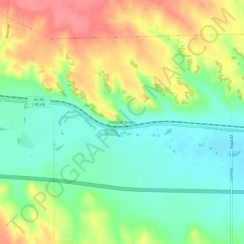
Name: Point of Rocks topographic map, elevation, terrain.

Location: Point of Rocks, Cheyenne County, Nebraska, United States (41.19026 -103.26604 41.23026 -103.22604)

Average elevation: 4,396 ft

Minimum elevation: 4,285 ft

Maximum elevation: 4,551 ft

Cheyenne County trails, hiking, mountain biking, running and outdoor activities

Other topographic maps

Click on a map to view its topography, its elevation and its terrain.

Sidney

United States > Nebraska > Cheyenne County

Average elevation: 4,160 ft

Gear up for your next adventure:

🧢Sun Protection Hats - Wide-brimmed and UPF-rated hats for high-altitude sun safety
🛌Ultralight Sleeping Bags - Compact down bags for cold nights in the wilderness
🏕️Tent Footprint - Protect your tent base from wear
GPS Sports Watch - GPS watch for running, hiking and training
👟Men's Trail Runners - Lightweight footwear for fast-paced exploration and light hiking

As an Amazon Associate, this site earns from qualifying purchases at no extra cost to you.